2023-05-29 12.01.18 copy.jpg
From Underfoot
Size of this preview: 800 × 589 pixels. Other resolutions: 320 × 235 pixels | 640 × 471 pixels | 1,024 × 753 pixels | 1,280 × 942 pixels | 2,059 × 1,515 pixels.
Original file (2,059 × 1,515 pixels, file size: 607 KB, MIME type: image/jpeg)
This file is from Wikimedia Commons and may be used by other projects. The description on its file description page there is shown below.
This map image could be re-created using vector graphics as an SVG file. This has several advantages; see Commons:Media for cleanup for more information. If an SVG form of this image is available, please upload it and afterwards replace this template with
{{vector version available|new image name}}.It is recommended to name the SVG file “2023-05-29 12.01.18 copy.svg”—then the template Vector version available (or Vva) does not need the new image name parameter. |
This map image was uploaded in the JPEG format even though it consists of non-photographic data. This information could be stored more efficiently or accurately in the PNG or SVG format. If possible, please upload a PNG or SVG version of this image without compression artifacts, derived from a non-JPEG source (or with existing artifacts removed). After doing so, please tag the JPEG version with {{Superseded|NewImage.ext}} and remove this tag. This tag should not be applied to photographs or scans. If this image is a diagram or other image suitable for vectorisation, please tag this image with {{Convert to SVG}} instead of {{BadJPEG}}. If not suitable for vectorisation, use {{Convert to PNG}}. For more information, see {{BadJPEG}}. |
Summary
| Description2023-05-29 12.01.18 copy.jpg |
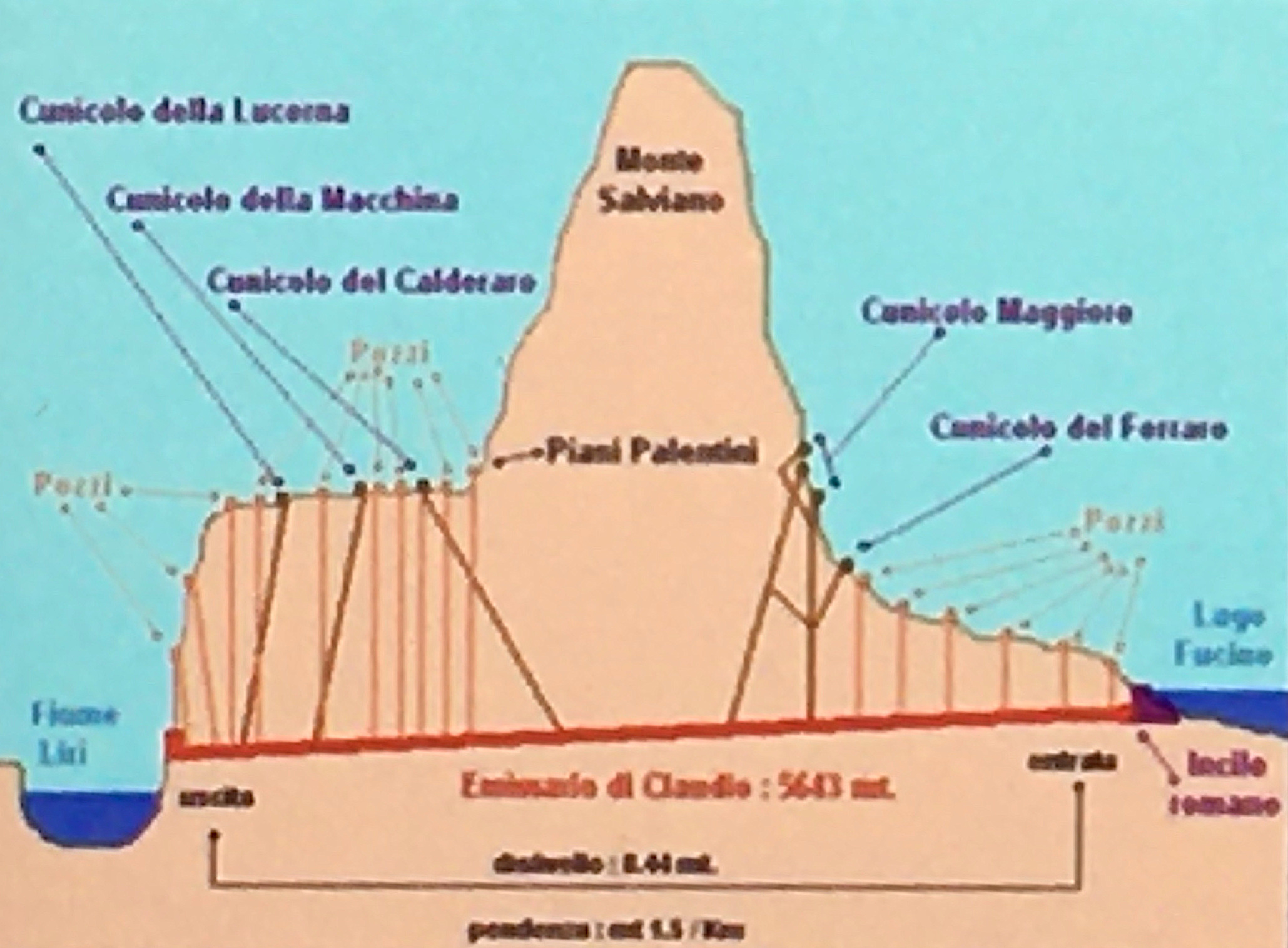
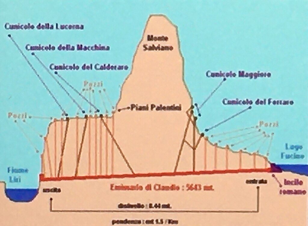
English: Tunnel of Claudius |
| Date | |
| Source | Own work |
| Author | Rjdeadly |
| Camera location | 41° 59′ 21.3″ N, 13° 26′ 08.55″ E | View this and other nearby images on: OpenStreetMap |
|---|
Licensing
I, the copyright holder of this work, hereby publish it under the following licence:
This file is licensed under the Creative Commons Attribution-Share Alike 4.0 International licence.
- You are free:
- to share – to copy, distribute and transmit the work
- to remix – to adapt the work
- Under the following conditions:
- attribution – You must give appropriate credit, provide a link to the licence, and indicate if changes were made. You may do so in any reasonable manner, but not in any way that suggests the licensor endorses you or your use.
- share alike – If you remix, transform, or build upon the material, you must distribute your contributions under the same or compatible licence as the original.
Captions
Add a one-line explanation of what this file represents
Tunnel of Claudius
Items portrayed in this file
depicts
some value
41°59'21.30"N, 13°26'8.56"E
0.00378787878787878787 second
2.2
4.15 millimetre
image/jpeg
621,758 byte
1,515 pixel
2,059 pixel
8cb2f62b39587e241d23e6d985c8db7b1d118055
File history
Click on a date/time to view the file as it appeared at that time.
| Date/Time | Thumbnail | Dimensions | User | Comment | |
|---|---|---|---|---|---|
| current | 20:57, 11 June 2023 | 2,059 × 1,515 (607 KB) | wikimediacommons>Rjdeadly | Uploaded own work with UploadWizard |
File usage
There are no pages that use this file.
Metadata
This file contains additional information, probably added from the digital camera or scanner used to create or digitise it.
If the file has been modified from its original state, some details may not fully reflect the modified file.
| Camera manufacturer | Apple |
|---|---|
| Camera model | iPhone 6s |
| Exposure time | 1/264 sec (0.0037878787878788) |
| F Number | f/2.2 |
| ISO speed rating | 25 |
| Date and time of data generation | 12:01, 29 May 2023 |
| Lens focal length | 4.15 mm |
| Latitude | 41° 59′ 21.3″ N |
| Longitude | 13° 26′ 8.55″ E |
| Altitude | 695.575 metres above sea level |
| Orientation | Normal |
| Horizontal resolution | 300 dpi |
| Vertical resolution | 300 dpi |
| Software used | GIMP 2.10.32 |
| File change date and time | 21:40, 11 June 2023 |
| Exposure Program | Normal program |
| Exif version | 2.32 |
| Date and time of digitising | 12:01, 29 May 2023 |
| Meaning of each component |
|
| APEX shutter speed | 8.0454909819639 |
| APEX aperture | 2.2750070480205 |
| APEX brightness | 7.458364906963 |
| APEX exposure bias | 0 |
| Metering mode | Pattern |
| Flash | Flash did not fire, compulsory flash suppression |
| DateTimeOriginal subseconds | 062 |
| DateTimeDigitised subseconds | 062 |
| Supported Flashpix version | 1 |
| Sensing method | One-chip colour area sensor |
| Scene type | A directly photographed image |
| Exposure mode | Auto exposure |
| White balance | Auto white balance |
| Digital zoom ratio | 5.0066225165563 |
| Focal length in 35 mm film | 146 mm |
| Scene capture type | Standard |
| Speed unit | Kilometres per hour |
| Speed of GPS receiver | 0 |
| Reference for direction of image | True direction |
| Direction of image | 118.86699288256 |
| Reference for bearing of destination | True direction |
| Bearing of destination | 118.86699288256 |
| Unique ID of original document | xmp.did:f40536d7-6974-48da-8d25-d4b83067abdf |
| IIM version | 2 |
Retrieved from "https://underfoot.info/File:2023-05-29_12.01.18_copy.jpg"
