Abercwmeiddaw incline and mill.jpg
From Underfoot
Size of this preview: 798 × 599 pixels. Other resolutions: 320 × 240 pixels | 639 × 480 pixels | 1,023 × 768 pixels | 1,024 × 769 pixels.
Original file (1,024 × 769 pixels, file size: 788 KB, MIME type: image/jpeg)
This file is from Wikimedia Commons and may be used by other projects. The description on its file description page there is shown below.
Summary
| DescriptionAbercwmeiddaw incline and mill.jpg |
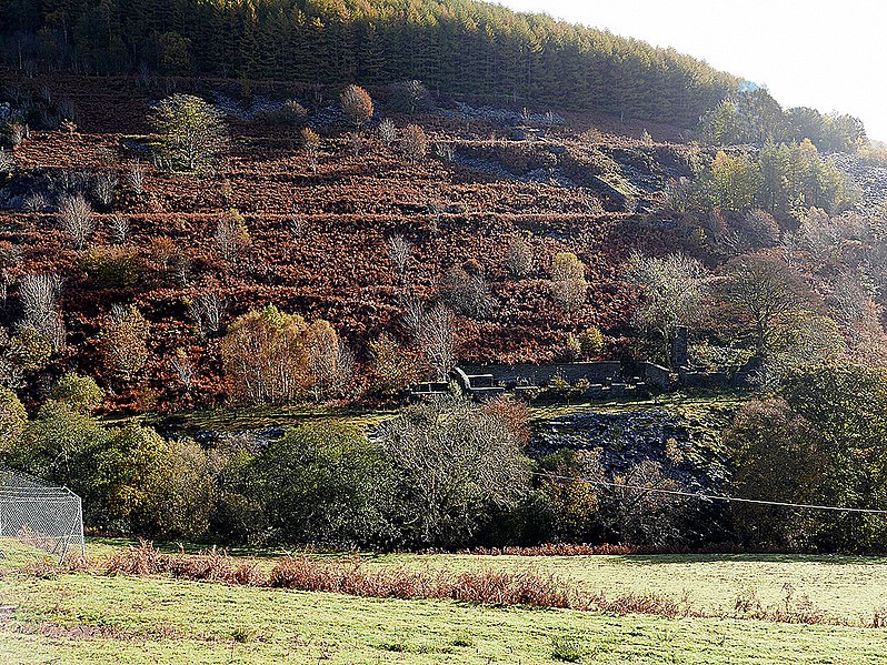
English: The remains of Abercwmeiddaw quarry in 2018, showing the partly dismantled mill and the trackbed of the original quarry incline |
| Date | |
| Source | https://www.geograph.org.uk/photo/5951799 |
| Author | John Lucas |
| Attribution (required by the licence) InfoField | John Lucas / Terraces of Abercwmeiddaw Slate Quarry / |
InfoField | John Lucas / Terraces of Abercwmeiddaw Slate Quarry |
| Camera location | 52° 39′ 56.8″ N, 3° 51′ 31.91″ W | View this and other nearby images on: OpenStreetMap |
|---|
Licensing
This image was taken from the Geograph GB & Eire project collection. See this photograph's page on the Geograph website for the photographer's contact details. The copyright on this image is owned by John Lucas, and is licensed for reuse under the Creative Commons Attribution Share-Alike 2.0 license.
|
This file is licensed under the Creative Commons Attribution-Share Alike 2.0 Generic licence.
Attribution:
John Lucas
- You are free:
- to share – to copy, distribute and transmit the work
- to remix – to adapt the work
- Under the following conditions:
- attribution – You must give appropriate credit, provide a link to the licence, and indicate if changes were made. You may do so in any reasonable manner, but not in any way that suggests the licensor endorses you or your use.
- share alike – If you remix, transform, or build upon the material, you must distribute your contributions under the same or compatible licence as the original.
Captions
Add a one-line explanation of what this file represents
The remains of Abercwmeiddaw quarry in 2018
Items portrayed in this file
depicts
22 October 2018
52°39'56.797"N, 3°51'31.907"W
image/jpeg
ad38e5d02a89e63dbfd3e3c8992b834054a85d05
806,634 byte
769 pixel
1,024 pixel
52°39'56.2"N, 3°51'24.5"W
0.005 second
5.6
200
15.9 millimetre
File history
Click on a date/time to view the file as it appeared at that time.
| Date/Time | Thumbnail | Dimensions | User | Comment | |
|---|---|---|---|---|---|
| current | 18:03, 1 September 2019 | 1,024 × 769 (788 KB) | wikimediacommons>The Mirror Cracked | User created page with UploadWizard |
File usage
There are no pages that use this file.
Metadata
This file contains additional information, probably added from the digital camera or scanner used to create or digitise it.
If the file has been modified from its original state, some details may not fully reflect the modified file.
| Camera manufacturer | Panasonic |
|---|---|
| Camera model | DMC-LX100 |
| Author | Picasa |
| Exposure time | 1/200 sec (0.005) |
| F Number | f/5.6 |
| ISO speed rating | 200 |
| Date and time of data generation | 11:23, 22 October 2018 |
| Lens focal length | 15.9 mm |
| Latitude | 52° 39′ 56.8″ N |
| Longitude | 3° 51′ 31.91″ W |
| Altitude | 211 metres above sea level |
| Orientation | Normal |
| Horizontal resolution | 180 dpi |
| Vertical resolution | 180 dpi |
| Software used | Adobe Photoshop 7.0 |
| File change date and time | 08:16, 24 October 2018 |
| Y and C positioning | Co-sited |
| Exposure Program | Landscape mode (for landscape photos with the background in focus) |
| Exif version | 2.3 |
| Date and time of digitising | 11:23, 22 October 2018 |
| Meaning of each component |
|
| Image compression mode | 4 |
| APEX exposure bias | 0 |
| Maximum land aperture | 2.40234375 APEX (f/2.3) |
| Metering mode | Pattern |
| Light source | Unknown |
| Flash | Flash did not fire, compulsory flash suppression |
| DateTime subseconds | 421 |
| DateTimeOriginal subseconds | 421 |
| DateTimeDigitised subseconds | 421 |
| Supported Flashpix version | 1 |
| Colour space | sRGB |
| Sensing method | One-chip colour area sensor |
| File source | Digital still camera |
| Scene type | A directly photographed image |
| Custom image processing | Normal process |
| Exposure mode | Auto exposure |
| White balance | Auto white balance |
| Digital zoom ratio | 0 |
| Focal length in 35 mm film | 35 mm |
| Scene capture type | Standard |
| Scene control | Low gain up |
| Contrast | Normal |
| Saturation | Normal |
| Sharpness | Normal |
| Unique image ID | 3ada753322c7bc997e136b74b81c2f44 |
| Geodetic survey data used | WGS-84 |
| GPS tag version | 0.0.2.2 |
| IIM version | 2 |
Retrieved from "https://underfoot.info/File:Abercwmeiddaw_incline_and_mill.jpg"