Higher Kiln Quarry Caves - geograph.org.uk - 1097485.jpg
From Underfoot
No higher resolution available.
Higher_Kiln_Quarry_Caves_-_geograph.org.uk_-_1097485.jpg (640 × 427 pixels, file size: 120 KB, MIME type: image/jpeg)
Summary
| Description |
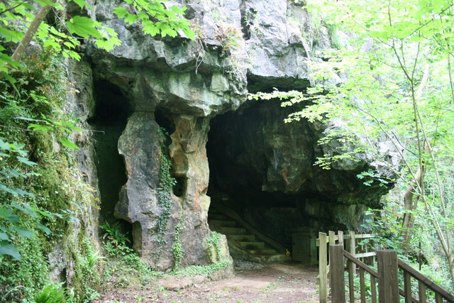
English: Higher Kiln Quarry Caves. These caves are in an outcrop of limestone on the edge of the granite aureole of Dartmoor. They were found as the limestone was quarried many years ago, and are now listed as SSSI because of their importance. This cave is called the Joint Mitnor cave after the local men who first explored it. Access can only be made through the William Pengelly Cave Studies Trust [1]. See 1097493. |
| Date | |
| Source | From geograph.org.uk |
| Author | Adrian Platt |
| Attribution (required by the licence) | Adrian Platt / Higher Kiln Quarry Caves / |
| Camera location | | View this and other nearby images on: OpenStreetMap |
|---|
_heading:225.00&language=en-gb)
| Object location | | View this and other nearby images on: OpenStreetMap |
|---|
_heading:225.00&language=en-gb)
Licensing

|
This image was taken from the Geograph GB & Eire project collection. See this photograph's page on the Geograph website for the photographer's contact details. The copyright on this image is owned by Adrian Platt, and is licensed for reuse under the Creative Commons Attribution Share-Alike 2.0 license.
|
This file is licensed under the Creative Commons Attribution-Share Alike 2.0 Generic licence.
Attribution:
Adrian Platt
- You are free:
- to share – to copy, distribute and transmit the work
- to remix – to adapt the work
- Under the following conditions:
- attribution – You must give appropriate credit, provide a link to the licence, and indicate if changes were made. You may do so in any reasonable manner, but not in any way that suggests the licensor endorses you or your use.
- share alike – If you remix, transform, or build upon the material, you must distribute your contributions under the same or compatible licence as the original.
File history
Click on a date/time to view the file as it appeared at that time.
| Date/Time | Thumbnail | Dimensions | User | Comment | |
|---|---|---|---|---|---|
| current | 14:23, 24 February 2011 | | 640 × 427 (120 KB) | wikimediacommons>GeographBot | == {{int:filedesc}} == {{Information |description={{en|1=Higher Kiln Quarry Caves These caves are in an outcrop of limestone on the edge of the granite aureole of Dartmoor. They were found as the limestone was quarried many years ago, and are now listed a |
File usage
The following 41 pages use this file:
- Silverbrook Mine
- Clerk's Tunnel
- Coryton Tunnel
- Kennaway Tunnel
- Greenway Tunnel
- Parson's Tunnel
- Shaugh Tunnel
- Shillamill Tunnel
- Morwellham Quay
- Plymouth Borough Control
- Plymouth Emergency Centre
- Hermerdon Ball mine
- Cow Cave
- Pixie's Hole
- Gawton arsenic mine and flue
- Windmill Hill Cavern
- Worth's Cattedown Bone Cave 150m north of Cattedown Wharves
- Ash Hole Cavern
- Okeltor 19th century arsenic, copper and tin mine
- Keaglesborough Mine and Riddipit farmstead 850m north east of Norsworthy Bridge
- Wheal Katherine, 235m west of Plym Ford, forming an outlying part of Eylesbarrow Tin Mine
- Foxhole Mine and other tinworks south east of Arms Tor
- George and Charlotte Copper Mine
- Grotto South East Of Oldway Mansion
- Engine House And Chimney At Druid Copper Mine
- United Kingdom cave
- Joint Mitnor Cave
- Sharkham Point Iron Mine
- Bakers Pit
- Birch Tor and Vitifer mine
- Crownhill Fort
- Devon United Mine
- Eylesbarrow mine
- Great Rock Mine
- Hemerdon Mine
- Kitley Show Cave
- Kelly Mine, Devon
- Pridhamsleigh Cavern
- Radford Cave
- Reed's cave
- Kents Cavern