Mine, what mine^ - geograph.org.uk - 823553.jpg
From Underfoot
No higher resolution available.
Mine,_what_mine^_-_geograph.org.uk_-_823553.jpg (640 × 417 pixels, file size: 70 KB, MIME type: image/jpeg)
Summary
| Description |
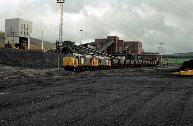
English: A pair of British Railways Class37 locomotives load coal on to an MGR train at the already closed Abernant Colliery "super pit" in the River Amman Valley. A reminder of South Wales once great Industrial past. Coal mines such as this were once found all over. Now there are no deep mines at all in South Wales. The colliery closed in 1988, and this location has been razed to the ground and the railway removed |
| Date | |
| Source | From geograph.org.uk |
| Author | roger geach |
| Attribution (required by the licence) | roger geach / Mine, what mine? / |
| Camera location | | View this and other nearby images on: OpenStreetMap |
|---|
_heading:202.00&language=en-gb)
| Object location | | View this and other nearby images on: OpenStreetMap |
|---|
_heading:202.00&language=en-gb)
Licensing

|
This image was taken from the Geograph GB & Eire project collection. See this photograph's page on the Geograph website for the photographer's contact details. The copyright on this image is owned by roger geach, and is licensed for reuse under the Creative Commons Attribution Share-Alike 2.0 license.
|
This file is licensed under the Creative Commons Attribution-Share Alike 2.0 Generic licence.
Attribution:
roger geach
- You are free:
- to share – to copy, distribute and transmit the work
- to remix – to adapt the work
- Under the following conditions:
- attribution – You must give appropriate credit, provide a link to the licence, and indicate if changes were made. You may do so in any reasonable manner, but not in any way that suggests the licensor endorses you or your use.
- share alike – If you remix, transform, or build upon the material, you must distribute your contributions under the same or compatible licence as the original.
File history
Click on a date/time to view the file as it appeared at that time.
| Date/Time | Thumbnail | Dimensions | User | Comment | |
|---|---|---|---|---|---|
| current | 16:15, 20 February 2011 | | 640 × 417 (70 KB) | wikimediacommons>GeographBot | == {{int:filedesc}} == {{Information |description={{en|1=Mine, what mine? A reminder of South Wales once great Industrial past. Coal mines such as this were once found all over. Now there are no deep mines at all in South Wales. This location has been raz |
File usage
More than 100 pages use this file. The following list shows the first 100 pages that use this file only. A full list is available.
- Cae-Sara Lead Mine
- Pen-Y-Garreg
- Vale Of Towy Lead Mine
- Pencoed Lead Works
- Aberdare Merthyr Colliery
- Aber-gelli Colliery
- Abergorky Quarry III, Coal Level I
- Abergorky Quarry III, Coal Level II
- Aberpergwm Mine
- Achddu Colliery, Burry Port
- Ammanford Colliery, Ammanford
- Avon Colliery
- Beili-glas Colliery
- Berthlwyd Colliery
- Bishwell Colliery
- Blaenant Colliery
- Blaencaerau Colliery
- Blaencorrwg Colliery
- Blaengarw Colliery
- Blaengrenig Coal Mine
- Blaen Ogwr
- Blaen-y-cwm Colliery
- Boundary Level Colliery
- Box Colliery
- Bres Pit
- Brithdir And Cwmdu Colliery
- Broadoak Colliery
- Bronbil Colliery And Tramway
- Bryn Carnarvon
- Bryn Colliery
- Bryn Defaid Coal Mine
- Bryn-dewi Colliery
- Brynlliw Colliery
- Bryn-mawr Colliery
- Budd's Rock Colliery
- Bynea Colliery
- Cae'r-elm Coal Pit, Sandy, Llanelly
- Cae Colliery
- Caeduke Colliery, Loughor
- Caemain Pit
- Caer-gynydd Colliery
- Caernarfon Coal Pit
- Cefn Arda Pit
- Cefn-bychan Colliery
- Cefncoed Colliery
- Cefn-goleu Colliery
- Cefn-mawr Colliery
- Cilfig Pit
- Cille Colliery
- Clyne Valley Colliery
- Clyne Valley Shaft Mounds, Swansea
- Clyn Gwernen Pit
- Coalbrook, Old Coal Pit
- Coal Levels, Maes Mawr, Pontyberem
- Cwm-clydach Graigola Colliery
- Cilfrew Colliery
- Colliery, Cockett, Swansea
- Colliery, Pen-clawdd
- Colliery, Three Crosses
- Colliery, Waunarlwydd
- Colliery Remains, Clydach Valley
- Corrwg Vale Colliery
- C Pit
- Craigavon Colliery
- Craiglon Colliery
- Craig-y-gigfran Coal Level, Aberdulais
- Crimea Colliery And Canal Quay, Ystalyfera
- Cwm-capel Colliery, Burry Port
- Cwmdare Colliery
- Cwm Garw, Coal Level
- Cwmgwineu Colliery
- Cwm Mawr Coal Level, Bft
- Cynon Colliery
- Dare Colliery
- Darran Colliery
- D Pit
- Drum Colliery, Bft 3.1
- Drum Colliery, Coal Level 3, B
- Drum Colliery, Level 1, Bft (3
- Drum Colliery, Level 2, Bft (3
- Drum Colliery, Shaft 1, Bft 3.
- Drum Colliery, Shaft 2, Bft 3.
- Drum Colliery, Shaft 3, Bft 3.
- Drum Colliery, Shaft 4, Bft 3.
- Dulais Resolven Colliery
- Dulas Colliery
- Dunraven Adare Colliery
- Dunvant Penlan Collieries
- Dunvant Penlan Colliery
- Dyffryn Main Colliery
- Dyffryn Rhondda Colliery
- Dynant Colliery
- Dynevor Main Colliery
- East Pit East Opencast Coal Site
- Emlyn Colliery, Pen-y-groes
- Empire Colliery
- Felin Fach Colliery
- Felin Fran Colliery
- Dan yr Ogof
- Cefn Coed Colliery Museum
View more links to this file.