Pit at Rosebush slate quarry - geograph.org.uk - 293408.jpg
From Underfoot
No higher resolution available.
Pit_at_Rosebush_slate_quarry_-_geograph.org.uk_-_293408.jpg (640 × 480 pixels, file size: 155 KB, MIME type: image/jpeg)
Summary
| Description |
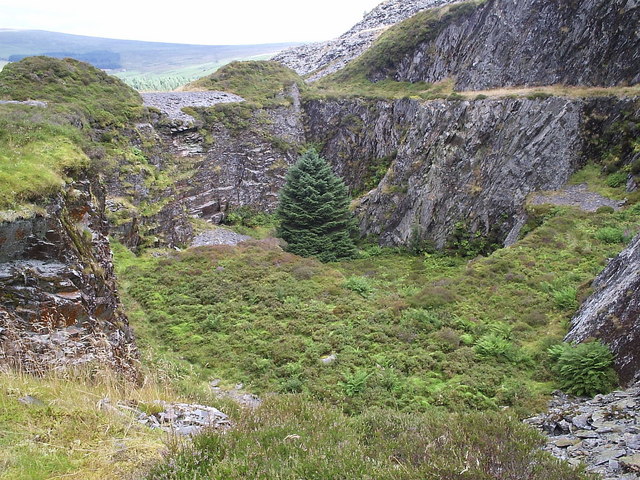
English: Pit at Rosebush slate quarry This pit is the deepest part of the southern working of the quarry, with a further 5 levels above. It was drained by an adit. The quarry was opened 1842 and reached its peak after the construction of a railway link with Clynderwen in the 1870's, with activity falling off by the end of the century. Now overgrown, it is an excellent place for gathering whinberries. |
| Date | |
| Source | From geograph.org.uk |
| Author | ceridwen |
| Attribution (required by the licence) | ceridwen / Pit at Rosebush slate quarry / |
| Camera location | | View this and other nearby images on: OpenStreetMap |
|---|
_heading:22.00&language=en-gb)
| Object location | | View this and other nearby images on: OpenStreetMap |
|---|
_heading:22.00&language=en-gb)
Licensing

|
This image was taken from the Geograph GB & Eire project collection. See this photograph's page on the Geograph website for the photographer's contact details. The copyright on this image is owned by ceridwen, and is licensed for reuse under the Creative Commons Attribution Share-Alike 2.0 license.
|
This file is licensed under the Creative Commons Attribution-Share Alike 2.0 Generic licence.
Attribution:
ceridwen
- You are free:
- to share – to copy, distribute and transmit the work
- to remix – to adapt the work
- Under the following conditions:
- attribution – You must give appropriate credit, provide a link to the licence, and indicate if changes were made. You may do so in any reasonable manner, but not in any way that suggests the licensor endorses you or your use.
- share alike – If you remix, transform, or build upon the material, you must distribute your contributions under the same or compatible licence as the original.
File history
Click on a date/time to view the file as it appeared at that time.
| Date/Time | Thumbnail | Dimensions | User | Comment | |
|---|---|---|---|---|---|
| current | 21:42, 14 December 2010 | | 640 × 480 (155 KB) | wikimediacommons>GeographBot | == {{int:filedesc}} == {{Information |description={{en|1=Pit at Rosebush slate quarry This pit is the deepest part of the southern working of the quarry, with a further 5 levels above. It was drained by an adit. The quarry was opened 1842 and reached its |
File usage
The following 53 pages use this file:
- Llanfyrnach Lead Mine
- Bedlam Pit: Spoil Heap & Pithead Site
- Black Cliff Colliery
- Castle Gate Pit, Amroth
- Castle Park Colliery: Pithead Remains
- Cwms Farm: Adit Spoil Heap
- Engine House And Shaft, Landshipping Colliery
- Garden Pit, Landshipping Colliery
- Little Milford Cuttings, Little Milford, Haverfordwest
- Middle Pit: Site Of Former Pit
- Old Coal Pit, Landingshipping Colliery
- Old Coal Pit, Landshipping Colliery
- Old Coal Pits, Landshipping Colliery, Oxhouse Farm
- Old Coal Shaft, Little Milford
- Old Culm Pit, Picton Point
- Old Culm Pits, Broad Haven
- Stumpy Corner: Pit
- Trefran Cliff Colliery
- William's Pit: Site Of Pit Head
- Maenclochog Tunnel
- Porthgain Quarry and Harbour
- Hoyle Mouth Cave
- Priory Farm Cave
- Underhill Wood Primitive Coal Workings
- Llanion Barracks Anti-Aircraft Operations Room
- Porthgain Stone Quarry
- Hanton Coastal Quarries
- Long Wood Quarries (Now Disused)
- Abercastell Quarries
- Disused Stone Quarry, Blaenweneirch
- Foxhill Colliery
- Woodland Colliery
- Hook Colliery
- Lower Tyrch Quarry
- Wogan Cavern
- United Kingdom quarry
- Rosebush quarry
- Saundersfoot Railway Tunnel (South)
- Saundersfoot Railway Tunnel (Middle )
- Saundersfoot Railway Tunnel (North )
- Remains of Grotto in Garden of Picton Castle
- Coed Cochion Quarry
- Loveston Colliery
- Tommy quarry
- Triffleton quarry
- Bellstone quarry
- Llandilo quarry
- Pant-y-Phillip quarry
- Brawdy quarry
- Cefn quarry
- Syke quarry
- Glogue quarry
- Tyrch quarry