Groeve De Coolen 2 Val-Meer Riemst 2.jpg
From Underfoot

Size of this preview: 800 × 599 pixels. Other resolutions: 320 × 240 pixels | 640 × 479 pixels | 1,024 × 767 pixels | 1,280 × 958 pixels | 2,560 × 1,917 pixels | 3,248 × 2,432 pixels.
Original file (3,248 × 2,432 pixels, file size: 3.23 MB, MIME type: image/jpeg)
Summary
| Description |
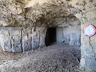
Nederlands: Groeve De Coolen in Riemst op de grens van de deelgemeentes Millen en Val-Meer is een mergelgroeve. Het gangenstelsel van meer dan 1 km heeft meerdere ingangen naast elkaar in een klein hellingbos.
English: Cave De Coolen in Riemst on the border of the districts Millen and Val-Meer is a marl quarry (limestone). The system of tunnels of more than 1 km has several entrances next to each other in a small sloping forest.
Français : Caves De Coolen à Riemst, à la frontière des districts de Millen et Val-Meer, est une carrière de craie. Le système de tunnels de plus d'un kilomètre comporte plusieurs entrées situées les unes à côté des autres dans une petite forêt à flanc de colline. |
| Date | |
| Source | Own work |
| Author | Eebie |
| OpenStreetMap | Node 3649612504 |
| Object location | | View this and other nearby images on: OpenStreetMap |
|---|
| Camera location | | View this and other nearby images on: OpenStreetMap |
|---|
Licensing
I, the copyright holder of this work, hereby publish it under the following licence:
This file is licensed under the Creative Commons Attribution-Share Alike 4.0 International licence.
- You are free:
- to share – to copy, distribute and transmit the work
- to remix – to adapt the work
- Under the following conditions:
- attribution – You must give appropriate credit, provide a link to the licence, and indicate if changes were made. You may do so in any reasonable manner, but not in any way that suggests the licensor endorses you or your use.
- share alike – If you remix, transform, or build upon the material, you must distribute your contributions under the same or compatible licence as the original.
File history
Click on a date/time to view the file as it appeared at that time.
| Date/Time | Thumbnail | Dimensions | User | Comment | |
|---|---|---|---|---|---|
| current | 19:25, 28 July 2022 | | 3,248 × 2,432 (3.23 MB) | wikimediacommons>Eebie | Uploaded own work with UploadWizard |
File usage
More than 100 pages use this file. The following list shows the first 100 pages that use this file only. A full list is available.
- Coal Mine of Winterslag
- Staatsmijn Maurits
- Sibbergroeve
- Coal mine museum Valkenburg
- Geulhemmergroeve
- Blegny-Mine
- limestone quarry
- Coal Mine of Eisden
- Coal Mine of Zwartberg
- Coal Mine of Waterschei
- Vallenberggroeve
- Société anonyme des Charbonnages de Maireux et Bas-Bois
- Société anonyme du Charbonnage du Bois de Micheroux
- Groeve boven op de Riesenberg
- Riesenberggroeve
- Groeve de Kleine Hel
- Groeve de Grote Hel
- Kleinberggroeve Noord
- Groeve aan Hiereberg
- Bakkersboschgroeve
- Oude Groeve Sint-Joseph
- Mosterdberggroeve Noord
- Hotsboomgroeve
- Groeve de Hel
- Varkensgatgroeve
- Groeve de Kleine Dolekamer
- Savelsberggroeve
- Groeve Scheggeldergrub II
- Lebensboschgroeve
- Groeve het Houbenbergske I
- Groeve het Houbenbergske II
- Strooberggroeve
- Winkelberggroeve
- Grindgroeve Krekelberg
- Bemelerbosgroeve I
- Mettenberggroeve I
- Mettenberggroeve II
- Mettenberggroeve V
- Koeberggroeve
- Meerssenergroeve
- Groeve Onder de Ravengroeve
- Schuncktunnel
- Groeve onder de Leeraarsgroeve
- Groeve in de Dolekamer
- Groeve het Paradijsbergske III
- Groeve het Paradijsbergske I
- Kloostergroeve
- Groeve Putberg
- Groeve bij de Drie Beeldjes
- Groeve Bovenste Bosch
- Groeve Bissen
- Grindgroeve Savelsbos
- Heidegroeve
- Heilig Hartgroeve
- Kerkhofsgroeve
- Wilhelminagroeve
- Hoorensberggroeve
- Gewandgroeve I
- Bieboschgroeve
- Groeve van de Verdwenen Honden
- Ingvarsputje
- Canadasbergske
- Sint-Jansboschheidegroeve
- Groeve het Kornelsbergske
- Sint-Jansboschgroeven
- Groeve Theunissen I
- Groeve Theunissen II
- Fallenberggroeve
- Scheuldergroeve III
- Groeve De Keel
- Groeve De Nieuwe Keel
- Grotwoning De Kluis
- Zwarte Berg
- Groeve onder de Keutenberg
- Groeve Gerendal
- Groeve van de Scheve Spar II
- Groeve Essenbosch III
- Neolithic flint mine Biebosch
- Groeve Scheggeldergrub III
- Kleinberggroeve Zuid
- Mosterdberggroeve Zuid
- Benzenradergroeve
- Craubeekergroeve
- Groeve Kaardenbeek
- Groeve het Paradijsbergske IIa
- Groeve het Paradijsbergske Ia
- Roothergroeve
- Vogelbosgroeve
- Carolusgroeve
- Oosterweggroeve II
- Groothofgroeve
- Heekerbeekgroeve
- Sint-Josephgroeve
- Bergkelders Villa Alpha
- Cadierdalgroeve III
- Sint-Jansboschgroeve II
- Sint-Jansboschgroeve III
- Sint-Jansboschgroeve IV
- Sint-Jansboschgroeve V
- Groeve naast Beckersbergske
View more links to this file.